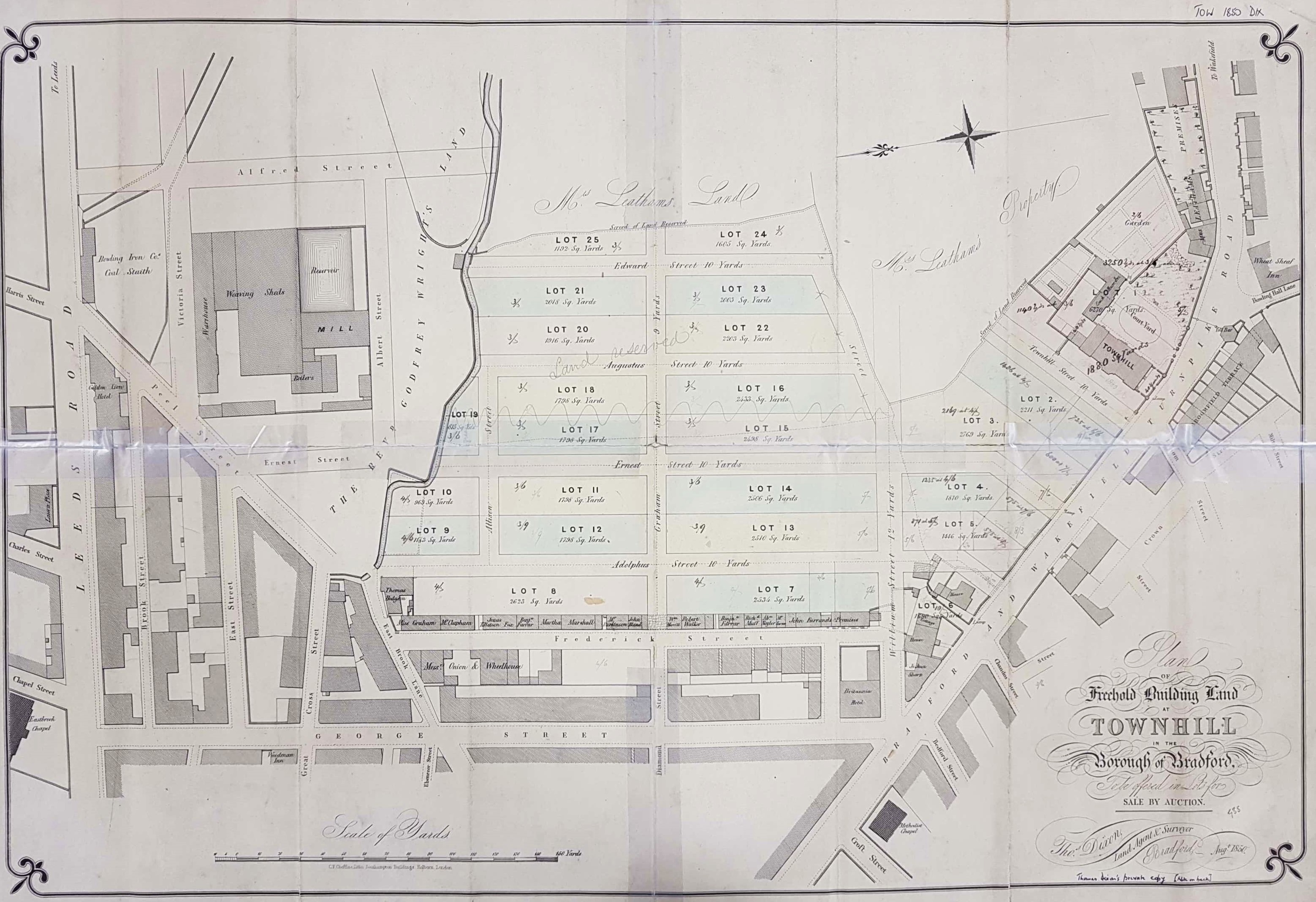
1.32 TOW 1850 DIX
Townhill Estate, Dixon & Hindle
Material: Paper Date: 1850 Scale: 20 yards: 1 inch
Size: 81 * 57cm Condition: Poor, minor repairs made.
The map is noteworthy as being dated (1850) and having a definite and known reason for its production: I’m even sure who the land-owner was. Better still, the year 1850 corresponds nicely with the first Ordnance Survey map of the Bradford area so there exists is an independent check of the layout.
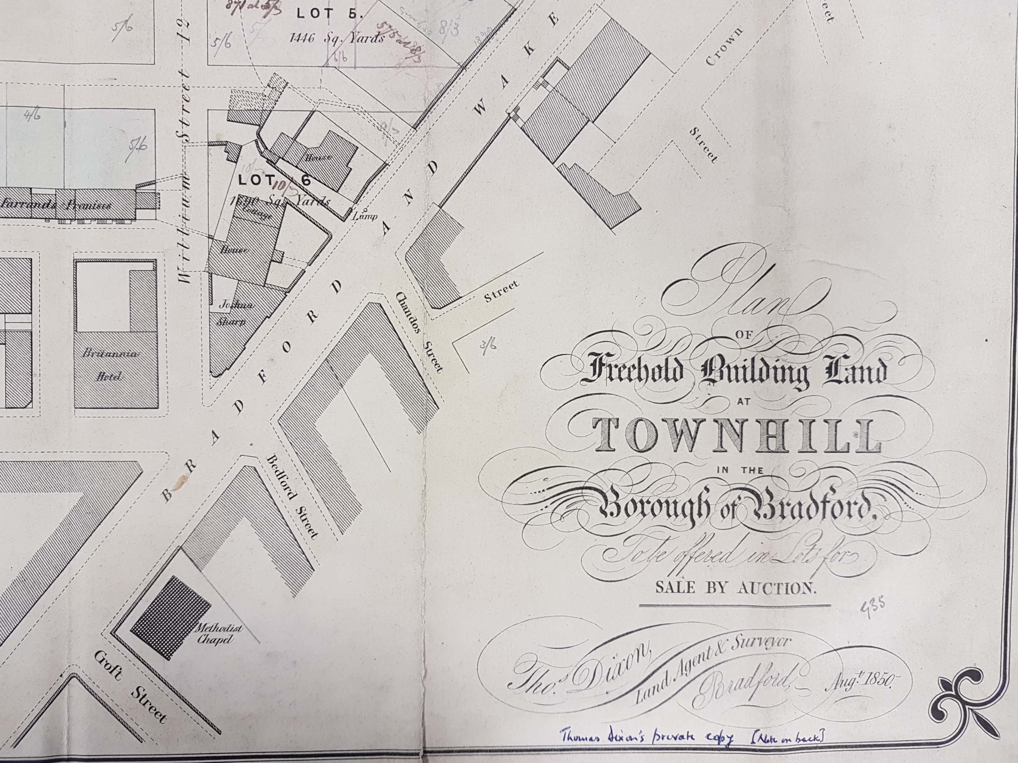
So, where are we? At the left of the map is Leeds Road. Perpendicular to it (just above the scale) is George Street at the other end of which is the Bradford & Wakefield Turnpike Road (Bridge Street – Wakefield Road). Only a stump of George Street now remains, the rest being lost in the Hollywood Bowl – Leisure Exchange development. Peel Street and East Brook Lane are in their correct positions. The watercourse is the East Brook and the whole area was once called Goodman’s End.
Evidently this plan was drawn to accompany an auction of freehold land presumably planned to take place for the same year. Searching through the Bradford Observer provides no evidence that the auction ever actually took place. The reason for this failure is quite clear. Although Frederick Street was constructed, parallel to and east of George Street, everything east of this road (above it on the plan) became, even by the time of the first OS map, the site of Adolphus Street railway station and its associated yards. The year 1854 is usually quoted for the opening of the station. The situation is made clear by a report in the Bradford Observer of 15th June that year. Seemingly a Dr Whitaker was seeking compensation from the Leeds, Bradford & Halifax Junction railway (which after several years of operation was by GNR) for the land required by them for their station. Mr T Dixon, our surveyor, is quite definitely stated to be Dr Whitaker’s agent. Dixon is reported as having laid out the Town Hill (sic) Estate in order for it to be sold off as building land. All the streets on our plan are mentioned in the report: William Street also being known as Dryden Street. Subsequent accounts in the newspaper suggest that dealing with irate land-owners was one of the major difficulties in the construction of the Leeds-Bradford line. Disappointingly I cannot, at present, establish who exactly Dr Whitaker was, nor whether he was a medical doctor or a doctor of divinity. His surname is that of a well-known Bradford brewing family.

It is a struggle to reconcile this map with modern Bradford, but then this is not an unfamiliar experience. Even the name Townhill is unfamiliar although Town Hill House once existed and can be seen top right of the map. Woolstapler John Buck lived there in the late eighteenth century just prior to his becoming a Bradford Canal promoter. His classical house was near a toll-booth at the bottom of Wakefield Road. This area was clearly used in the nineteenth century for the site of the engine sheds and railway yards which are present on the 1889 OS map.
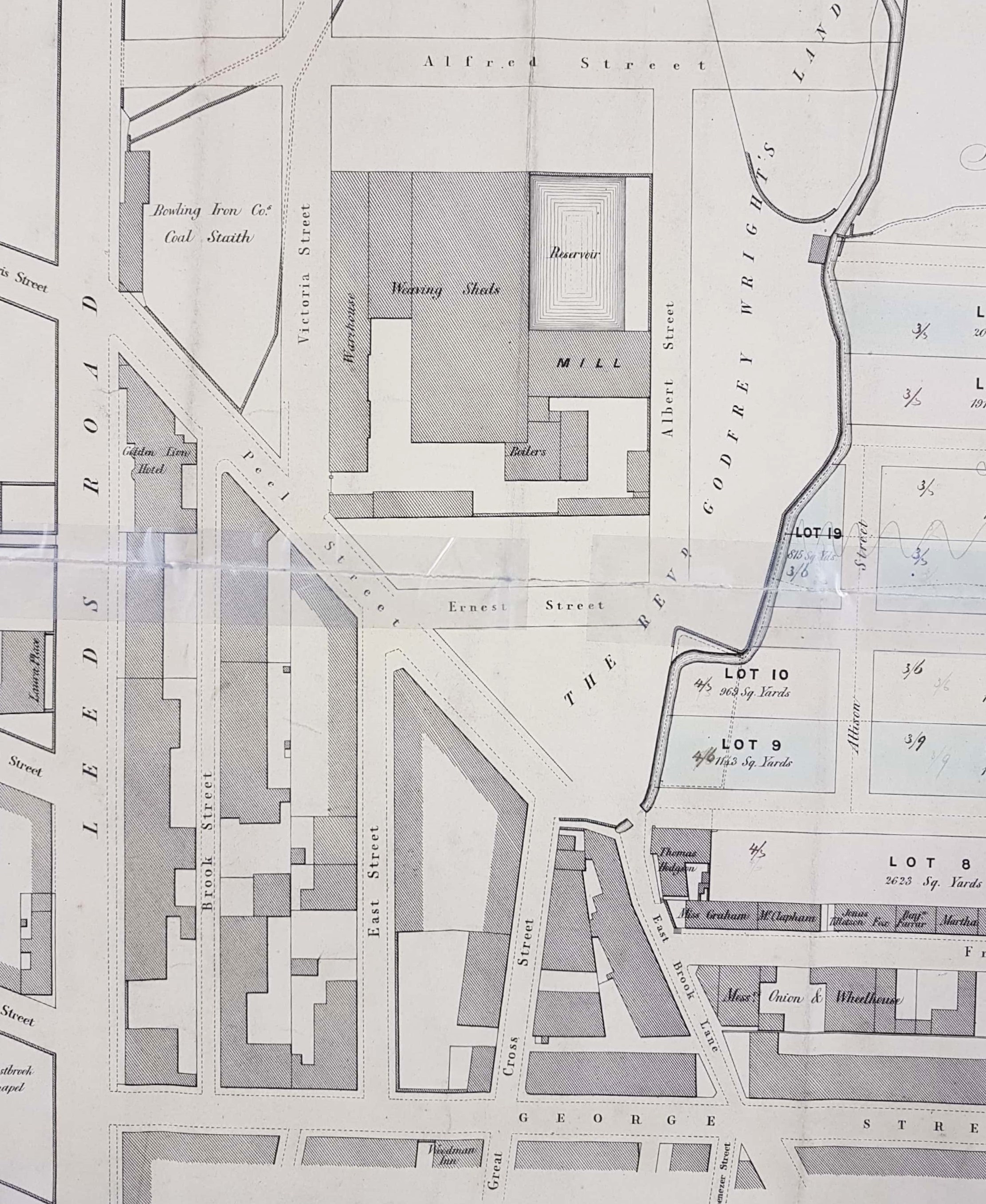
Two industrial concerns are of interest: the Bowling Iron Works coal staithe and a textile mill. A coal staithe is a place adjacent to a highway from which merchants can collect a supply for subsequent delivery to their customers. In an earlier map the staithe here is marked J.S. & Co. Clearly this represents John Sturges (or Sturgess) & Co. which was the company that operated Bowling Iron Works. No way of transporting coal is drawn on the map but there was a mineral carrying tramway bringing trucks to the Eastbrook staithe, by rope haulage, from the iron works. The trucks may have been returned filled with limestone, needed for iron smelting, which would have arrived at the nearby canal basin from the quarries at Skipton. The tramway was closed in 1846 and the area is marked as an ‘old staithe’ in the first OS map of the area, adjacent to the Golden Lion Inn.
The textile factory was a large concern. A mill usually contains spinning machines; worsted is woven in a shed. Both are present here. The premises are named, reasonably enough, East Brook Mill (a.k.a Eastbrook Mills) in the first OS map. The mill was built in 1844 by Swithin Anderton (1803-1860). Anderton is buried in Undercliffe Cemetery and Cudworth records that he was one of the first town councillors and was also, I believe, a director of the Leeds, Bradford and Halifax Junction Railway. St James’s Market was built east of East Brook Mill in the 1870s.
Two important adjacent landowners are mentioned on the map: Rev Godfrey Wright and Mrs Leatham. Godfrey Charles Wright (1780-1862) owned land all over the district in the mid-19th century. You will see his name in maps of Bradford, Horton, Manningham, Baildon, Otley and elsewhere. Wright does not seem to have lived in Bradford itself for any prolonged period, if at all. Certainly by 1822 he resided at Bilham House, Hooton Pagnell. S.Yorks where he stayed for the next 40 years. In census reports he describes himself as ‘clergyman without cure of souls’. Mrs Leatham is not even afforded the dignity of an initial on the map. The Leathams were a distinguished Quaker family associated with Heath near Wakefield. Edward Leatham was MP for Huddersfield and his brother William Henry Leatham (of Hemsworth Hall) was MP for Wakefield. Their sister Margaret Leatham married John Bright. Both MPs were married but at the time of this map, and for decades after, were very much alive. Their mother Margaret Leatham (1793-1871) was the daughter of Dr Joshua Walker of Leeds. She married William Leatham (1784-1842) and thus would have been a widow for nearly 30 years. The probate on her estate was in the class of ‘under £40,000’ so she was almost certainly a land-owner and is likely to have been the ‘Mrs Leatham’ referred to on the map.
