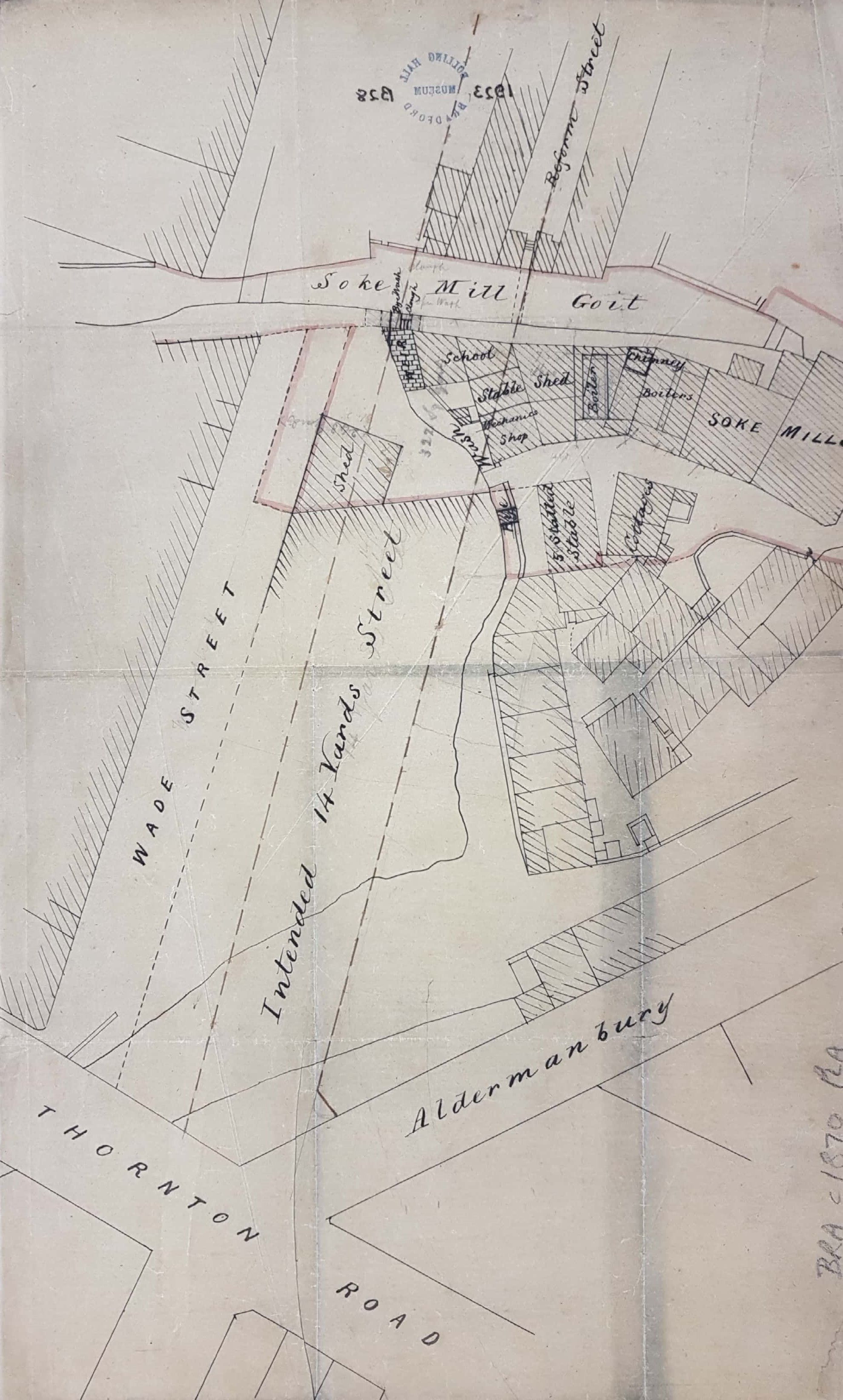
Soke Mill Goit & the creation of Godwin Street
Reserve map 2.32: BRA c1865 PLA: BHM 1923 B28
Tracing paper: Scale: none: Size: 42*30 cm: Condition: fair
Keywords: Godwin, Soke, Goitside, Aldermanbury, Ragged school
The main purpose of this plan is to record the position of a new street to be created from the Thornton Road/Aldermanbury junction. The new road is clearly Godwin Street although when actually constructed this thoroughfare was not so strictly parallel to Wade Street as the plan would suggest. The name Godwin was given in honour of Alderman Godwin, a recent mayor, and had been decided upon in 1866 (Bradford Observer, November 15 1866). My main interest is in the buildings and features that were to be swept away by the reorganisation. The Lord of the Manor had the medieval right to a corn-milling monopoly at the Soke Mill (later known as Queens Mill), which had stood above Aldermanbury for centuries. Bradford Corporation finally bought out this right in 1870. Soke Mill Goit took water from the Bradford Beck which provided power for the mill. The weir and Bye wash, clearly marked on the plan, were evidently mechanisms to regulate the flow of water through the Soke Mill’s waterwheels, although steam power was also available to the millers. The goit, like the Bradford Beck, is now culverted. The cluster of buildings round the mill includes a blacksmith’s forge, a mechanics shop and several stables. More surprisingly perhaps there is also a small school.
The plan is undated but mapping the creation of Godwin Street ensures a date before 1866. The buildings, including the school, between the Soke Mill and weir were constructed after to the 1851 OS map of the area. In fact roads and buildings in the area were re-fashioned several times between the years 1850-75, and you would need to be a much better local historian than me to provide a full account of the changes. Reform Street, seen here as a small stump, extended fully down to Thornton Road in an 1861 map and the district was known as St Helena. In an 1870 Bradford map Wade Street has now been laid out, but on a different alignment to the lower half of the earlier Reform Street. The topography is similar on our plan. I had hoped that dating the small school might be helpful in dating the plan, but first what type of school was it?
Clearly the school building is not the famous Bradford Grammar School. Board Schools were associated with the name of WE Forster, MP for Bradford and Minister for Education, but Forster’s Education Act was only passed in 1870 and the plan must pre-date that by around 5 years at least. Sunday Schools had been in existence since the late eighteenth century but non-conformist Sunday Schools were generally in the chapels or rooms adjoining, and the location of Anglican Schools are well-known and do not include Mill Bank. The same objection applies to Parochial Schools which were founded in Bradford after 1841 to educate the children of ‘the poor and working class’ in the principles of the Established Church. The Vicar, the Rev Dr Scoresby, was instrumental in their establishment in Heaton, Manningham, Eccleshill and elsewhere. None were situated near Mill Bank. The only possibility would seem to be a ‘ragged school’. This is a name applied to independently established nineteenth century charity schools which provided at least a degree of free education and often food, clothing and lodging for those too poor to pay. They were often found in the working-class areas of industrial towns. The term ‘ragged school’ is believed to have first been used by the London City Mission in 1840. By the mid-1850s a ‘Bradford Ragged School’ is described in Cropper Lane, Westgate which was soon being supported by the great and good of the borough. By the early-1860s there was a second ragged school nearby in Rebecca Street, Westgate. John James (History of Bradford) describes this as a larger replacement for the Cropper Lane institution. Rebecca Street still runs parallel to Westgate, south of Infirmary Field, and Cropper Lane is mapped connecting the city end of Rebecca Street to Westgate, close to St Thomas’s Church. There was a third school established in the Broomfields district which John James states was opened in 1858. None of these could, of course, explain the building on our plan. Although unmentioned by James evidently Messrs Ellis & Priestman first started an industrial & ragged school in ‘the neighbourhood of their mill’ in 1846 (Bradford Observer 17 September 1846). Messrs Ellis & Priestman were corn millers, the two men being related as brothers-in-law. The partnership had been in existence since the 1830s when, as Quakers, they were reported as opposing the payment of Church of England dues. They were listed as corn millers at Queens Mill, Millbank in the 1850 Ibbetson’s Directory so that the school in the plan is in a very plausible position. A subsequent newspaper report describes it as a ‘large garret’ for ‘destitute and vagrant’ children: no less than 160 were on the books.
The University of Leeds Special Collections has correspondence indicating that John Priestman was later instrumental in establishing a Quaker Day School, in 1850. The First Day School used the same premises as the Ragged School, but on Sundays, to teach reading, spelling and scripture knowledge. Some 69 children from very poor families in the local area were admitted. Writing was not taught until 1854, and evening classes began a few years later. John Priestman was the first superintendent of the school and on resigning in 1859, he was replaced by George Holt. In 1862, the whole school moved into purpose-built rooms at the Bradford Meeting House in Wakefield Road.
https://archiveshub.jisc.ac.uk/search/archives/7faae0ad-e367-3e31-8af5-d50b8db3440b
There can be little doubt that this is the school indicated on the map and the surveying for its production must have been undertaken between 1861-62. The Queens Mill (and associated property at Brown Royd Farm, Thornton Road) had been offered for sale on 27 November 1845. The Manningham Estate contained the reservoir that controlled the water flow in the goit. The mill building was seemingly not sold since the following year Ellis and Priestman set up their school in its neighbourhood. Possibly it was at this stage that they turned to their second career as textile manufacturers. What happened to Ellis and Priestman? In 1847 James Ellis travelled through Connemara with other Quakers witnessing the dire effects of the potato famine. The following year he sold up in Bradford and moved to Letterfrack in Ireland with his second wife Mary. He provided work and education for local people but was forced to return after about 10 years due to illness. John Priestman (1805-1866) lived at a house, now long demolished, named Whetley Hill. He was devoted to peace, and an enemy to none but strong drink. As I have said he was initially a flour miller and then a successful stuff weaver (John Priestman & Co.). He died at Whetley Hill in 1866 but his wife and sons continued in residence for a few years longer.
